
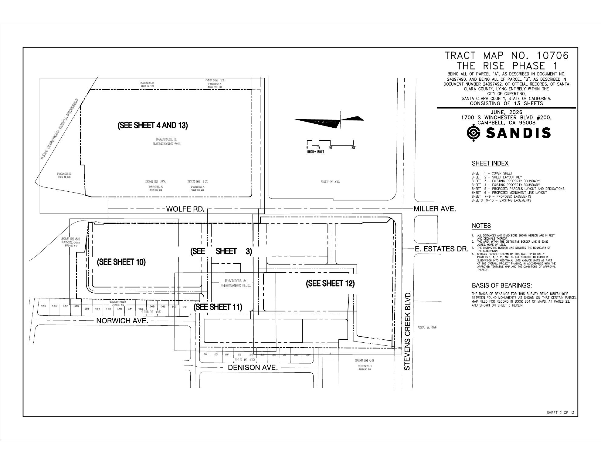
Updated August 2026: The transformation of the former Vallco Mall property has reached another important stage. On July 21, 2026, the Cupertino City Council reviewed and considered approval of Final Map Tract No. 10706 for Phase 1 of The Rise, along with public street dedications, easements and a detailed Subdivision Improvement Agreement covering infrastructure associated with the first phase.
This is not simply another conceptual rendering or redevelopment announcement. The documents now under review get into the mechanics of turning the approved project into actual parcels, streets, public-access areas, easements and infrastructure.
I reviewed the City's draft resolution, the accompanying Subdivision Improvement Agreement and the 13-sheet Phase 1 Final Map. Together, they provide one of the clearest looks yet at what the City is reviewing for the first phase of The Rise and what should happen next.
For ongoing construction, permit and development news, see my The Rise Cupertino Live Updates.
July 21, 2026: What Did the Cupertino City Council Review?
The item before the City Council concerned Final Map Tract No. 10706 for Phase 1 of The Rise at the former Vallco Mall property.
The draft resolution contemplated four important actions:
- Approval of Final Map Tract No. 10706 and authorization for its recordation;
- Acceptance of public roadway dedications and public easements shown on the Final Map;
- Abandonment of public easements the City determined were no longer necessary; and
- Authorization for the City Engineer to execute and record the project's Subdivision Improvement Agreement.
The draft resolution states that the Final Map is in substantial conformance with the previously approved Tentative Map and satisfies the requirements for approval under the California Subdivision Map Act and Cupertino Municipal Code.
An important distinction: the City document available for this review is a draft resolution. Although it is prepared for the July 21, 2026 meeting, the version reviewed has blank fields for the Council vote and signatures. For that reason, this article describes the July 21 milestone as the City reviewing and considering approval of the Final Map rather than treating the unsigned draft as evidence of final adoption.
That distinction matters when following a project this large. There is a difference between a proposal being placed before the City Council, a resolution being adopted, a Final Map being recorded and construction actually beginning.
See the Actual Phase 1 Final Map
The 13-sheet Final Map provides considerably more information than a project rendering. The overview below shows the Phase 1 subdivision in relation to North Wolfe Road, Stevens Creek Boulevard, Vallco Parkway, Norwich Avenue and Denison Avenue.
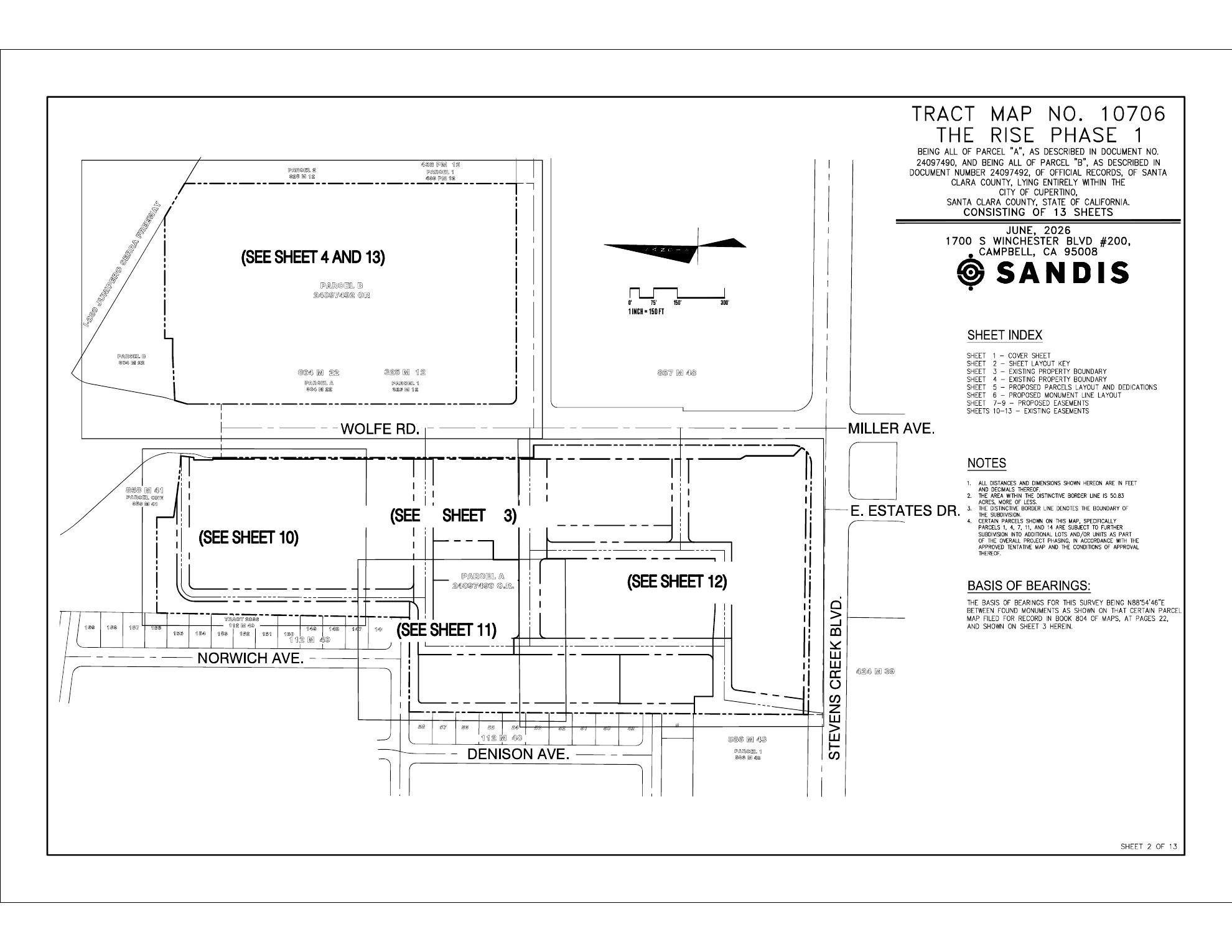
The Rise Phase 1 Final Map — Tract No. 10706. This overview shows the subdivision at the former Vallco Mall property and its relationship to Wolfe Road, Stevens Creek Boulevard and surrounding streets. Source: Phase 1 Final Map documents reviewed by the City of Cupertino, July 2026.
The overview is particularly useful because it shows that Phase 1 should not be thought of as a single building site. It covers a substantial portion of the former Vallco property and connects multiple development parcels with the surrounding street network.
What Is a Final Map?
A Final Map is much different from the architectural drawings and conceptual renderings that usually receive attention when a large development is announced.
At the Final Map stage, the project is being translated into legally defined parcels and infrastructure areas. Property boundaries, streets, rights-of-way, easements and other interests must be mapped so the approved development can move toward implementation.
For The Rise, that's significant.
The Vallco redevelopment story has spent years revolving around questions such as how many homes would be built, how much office space would remain, how affordable housing would be incorporated and what the project would eventually look like.
The Phase 1 Final Map deals with a different set of questions:
- Where are the actual parcels?
- Where will streets and public access run?
- What land or rights will be dedicated to the City?
- Where will public park and utility easements exist?
- What roadway improvements must the developer construct?
- What permits and security must be in place as infrastructure work proceeds?
Those are implementation questions rather than conceptual planning questions.
What Exactly Is Included in The Rise Phase 1?
The City's draft Subdivision Improvement Agreement identifies the Phase I Final Map as “Tract No. 10706, The Rise Phase I” and says the map was prepared by Sandis Civil Engineering.
The agreement describes Phase 1 as including:
- Parcel 1: Blocks 1 and 2
- Parcel 2: Block 3
- Parcel 3: Block 5
- Parcel 4: Block 4 and adjacent open-space and retail areas
- Parcel 5: Block 8
- Parcel 6: Block 7
- Parcel 7: Blocks 9, 10, 13 and 14
- Parcel 14: Block 6
- Associated streets, trails, dedication parcels and easements shown on the Final Map
The agreement also makes an important point that can easily get lost in summaries of the project: additional phased Final Maps are expected later.
The developer intends to file additional Final Maps for future phases and may further subdivide some of the parcels shown on this Phase 1 map.
So Tract No. 10706 is significant, but it should not be interpreted as the final subdivision map for every future component of The Rise.
A Closer Look at the Phase 1 Parcels
The detailed Final Map sheets show how the larger Phase 1 area is broken into individual parcels and how those parcels relate to the internal circulation system and surrounding streets. The 13-sheet set shows parcel boundaries, internal street alignments, and the easements within Tract No. 10706 in the same level of detail an engineering firm would use to stake the site.
This is one reason the Final Map review is more consequential than another project rendering. The map begins to show the physical framework upon which later buildings, public spaces, streets and infrastructure will depend.
The Infrastructure Work Along Wolfe Road and Stevens Creek Boulevard
One of the most useful parts of the City's Subdivision Improvement Agreement is its description of the Phase I Improvements the developer would be responsible for constructing.
The agreement specifically identifies improvements along North Wolfe Road, including work involving the center median north of Vallco Parkway and extending toward the existing median south of Vallco Parkway.
It also identifies improvements along Stevens Creek Boulevard and intersection work at:
- North Wolfe Road and Vallco Parkway
- North Wolfe Road and Stevens Creek Boulevard
- Stevens Creek Boulevard and Street A
These details matter to people who live near the project because some of the first highly visible evidence of implementation may occur around the streets and intersections surrounding the site rather than with a tower suddenly rising out of the ground.
Wolfe Road and Stevens Creek Boulevard are also two of the principal corridors through this part of Cupertino. Changes there can affect traffic circulation, pedestrian access, utilities and connections between The Rise and surrounding neighborhoods.
The City's Infrastructure Exhibit
The City's supporting documents also include exhibits associated with the land, roadway and infrastructure arrangements being considered as part of Phase 1, covering the roadway dedications, easements and infrastructure obligations tied to Tract No. 10706.
Together with the Final Map, these documents help explain why this stage is important. The City is no longer looking only at the location of future buildings. It is dealing with the underlying land, street and public-access framework necessary for those buildings and public spaces to function.
Public Access, Parks and Easements Are Part of the Review
The July documents also provide detail about the public and infrastructure easements associated with Phase 1.
The agreement identifies:
- Emergency Access Easements
- Public Access Easements
- Public Service Easements
- Public Park Easements
- Stormwater Management Easements
Some of these easements appear directly on the Final Map, while others may be granted through separate recorded agreements as the precise locations and technical details are finalized.
The agreement also anticipates that additional public park easements may be offered in Phase 1 or later phases.
This is an important piece of the redevelopment because The Rise is intended to function differently from the former Vallco Shopping Mall. Instead of one enclosed shopping center surrounded by large parking areas, the approved development is organized around multiple parcels, streets, walkways, public areas and mixed uses.
How Large Is The Rise Under the Current Approval?
The draft Subdivision Improvement Agreement provides a current snapshot of the overall project program.
It describes The Rise as allowing up to:
- 2,669 residential units
- 356 affordable residential units for lower-income households
- 2,700 total condominium units when residential and commercial/retail condominium units are counted together
- A minimum of 226,644 square feet of retail uses
- Up to approximately 1,474,946 square feet of office uses
Those are figures for the broader approved development. They should not be read as saying all 2,669 residences or the entire office and retail program will be constructed as part of this first infrastructure phase.
For the larger development picture, see my 95014 Real Estate and Development Guide and The Rise Cupertino and Town Square West guide.
A Six-Month Permit Provision Is Worth Watching
Buried deeper in the Subdivision Improvement Agreement is one of the more useful timing details.
Under the draft agreement, the developer would be required to submit applications for and diligently pursue permits for the initial Phase I Improvements within six months after the agreement becomes effective, subject to delays outside the developer's reasonable control or an extension approved by the City Engineer.
That does not mean Phase 1 has to be constructed within six months.
The agreement provides up to five years from issuance of permits authorizing the initial section of the Phase I Improvements for completion of those improvements, subject to the agreement's extension provisions. It also anticipates that construction may be completed in sections under a Schedule of Performance approved by the City Engineer.
That distinction is important:
Six months: pursue the initial permits after the agreement becomes effective.
Up to five years: contractual period for completion of the Phase I public improvements after issuance of the permits for the initial section, subject to the agreement's terms and possible extensions.
For people trying to determine whether The Rise is “really starting,” the permit applications and subsequent permit issuance are therefore milestones worth watching closely.
The Developer Would Be Financially Responsible for the Phase 1 Public Improvements
The draft agreement also makes clear that the developer, rather than the City, is responsible for furnishing, installing and constructing the Phase I Improvements at the developer's expense.
The agreement requires financial security for that work.
The required Performance Security is set at 100% of the estimated cost of constructing and installing the Phase I Improvements. A separate Labor and Materials Security is also set at 100% of the estimated construction and installation cost.
The amounts can be adjusted as more detailed plans and cost estimates become available through the building-permit process.
This is more than procedural paperwork. The security mechanism is intended to protect the City if required public improvements are not completed as agreed.
The agreement also allows the City, under specified default procedures, to draw upon the security and use those funds to complete required work if the developer fails to perform its obligations.
The City Doesn't Simply Accept the Infrastructure When It Is Built
The agreement establishes another layer of oversight after construction.
When the developer believes a Phase I improvement is complete, the City Engineer must determine whether the work substantially complies with the approved plans and City standards.
The developer remains responsible for the improvements until the City accepts them.
The agreement also includes warranty and security-release provisions. Among them, 90% of performance security may be released following City acceptance of the applicable improvements, while the remaining 10% is generally retained until one year after acceptance, provided deficiencies have been corrected and other requirements have been satisfied.
That gives us another useful distinction when following future announcements:
Construction completed and City acceptance are not necessarily the same milestone.
What Does All of This Mean for Town Square West?
Town Square West is expected to be the first major vertical development phase of The Rise.
The Final Map and Subdivision Improvement Agreement don't mean that every Town Square West building is now under construction. They deal with the subdivision, infrastructure, rights-of-way and other groundwork that helps make vertical development possible.
But there is an important shift taking place.
For years, the biggest Vallco questions were:
- Will the project be approved?
- How many homes will be built?
- How much affordable housing will there be?
- How much office space will remain?
- Will another redevelopment plan replace the current one?
Now we're increasingly talking about:
- Final Maps
- Individual parcels
- Road dedications
- Public easements
- Infrastructure agreements
- Improvement permits
- Construction sequencing
That doesn't guarantee a particular construction date. It does show that the City's review has moved into a more detailed implementation stage.
The Rise Has Already Been Modified Several Times
The City's July documents also put the current map into historical context.
The original SB 35 project and Tentative Map were approved in September 2018.
The City subsequently approved project modifications in:
- 2022 — first modification
- 2024 — second modification
- February 27, 2026 — third and most recent modification referenced in the July documents
The Phase 1 Final Map now being reviewed implements a portion of that previously approved Tentative Map.
For the full story of how the property moved from an aging shopping mall through years of redevelopment proposals to today's project, read From Vallco Mall to The Rise: A Look Back at One of Cupertino's Biggest Transformations.
And if you remember Vallco before all of the planning battles began, see 10 Things You Probably Forgot About Vallco Mall.
What Happens Next?
The July City documents give us a much better checklist for what to watch next.
The milestones I will be following include:
- Confirmation of final City action on Tract No. 10706;
- Recordation of the Phase 1 Final Map;
- Execution and recordation of the Subdivision Improvement Agreement;
- Applications for the initial Phase I public-improvement permits;
- Issuance of those permits;
- Road and intersection construction along Wolfe Road and Stevens Creek Boulevard;
- Work associated with the new internal streets;
- Building permits for the first vertical structures;
- Start of vertical construction at Town Square West;
- Additional phased Final Maps;
- Retail and restaurant tenant announcements.
I will continue adding confirmed developments to my The Rise Cupertino Live Updates rather than treating every new article or repeated announcement as a new project milestone.
Why This July 2026 Review Matters
The most important takeaway from the July documents isn't that The Rise has suddenly reached the finish line. It hasn't.
It's that the conversation is becoming increasingly concrete.
There are now detailed Final Map sheets showing parcels and streets. There is a proposed Subdivision Improvement Agreement describing specific work along Wolfe Road and Stevens Creek Boulevard. There are public-access, park and utility easements. There are permit deadlines, construction obligations, financial-security requirements and procedures for City inspection and acceptance.
Those aren't renderings of what The Rise might someday look like. They are documents dealing with how an approved project gets divided, serviced, permitted and built.
For a redevelopment that has been debated for years, that's an important stage to reach.
What The Rise Could Mean for Cupertino Real Estate
The Rise is large enough that its long-term effects won't stop at the former Vallco property line.
The addition of thousands of homes, new retail, public spaces and a new internal street network could change how buyers evaluate parts of central Cupertino near Wolfe Road and Stevens Creek Boulevard.
During construction, buyers and nearby homeowners will also have more immediate questions about traffic, road work, noise, access and construction sequencing.
Longer term, the questions may shift toward walkability, restaurants and retail, access to public spaces and how a new mixed-use district changes the relationship between surrounding residential neighborhoods and this portion of Stevens Creek Boulevard.
Those effects will take years to become clear, which is why I'll continue following the City's maps, permits and public documents as the project progresses.
Following The Rise or Buying a Home in Cupertino?
If you're considering buying or selling a home in Cupertino and want to understand how The Rise, Town Square West or another major development could affect a particular neighborhood, I can help you evaluate the location and the current market.
Bruce Wagg
Keller Williams Elevate
DRE #01760054
(669) 202-7777
Source Documents and Editorial Note
This article is based primarily on the City of Cupertino's July 2026 draft resolution and Subdivision Improvement Agreement for Final Map Tract No. 10706 and the accompanying 13-sheet The Rise Phase 1 Final Map.
The Final Map itself provides the detailed parcel, boundary, street and easement information discussed above. The draft City agreement provides the Phase I infrastructure obligations, including improvements along North Wolfe Road and Stevens Creek Boulevard and at the Wolfe/Vallco Parkway, Wolfe/Stevens Creek and Stevens Creek/Street A intersections. It also provides the six-month permit-application provision and the longer contractual period for completion of the Phase I improvements.
Editorial note: The draft resolution reviewed for this article contains blank Council vote and signature fields. Accordingly, this article describes the July 21, 2026 event as the City reviewing and considering approval of Final Map Tract No. 10706. It does not use the unsigned draft resolution as evidence that the proposed resolution was ultimately adopted. The draft resolution itself describes the actions being considered, including approval and recordation of the Final Map, roadway and easement actions, and authorization of the Subdivision Improvement Agreement.
Posted by Bruce Wagg onEnjoy this blog post? Click here to subscribe for updates
Leave A Comment